Qakerlualek Map
Description:
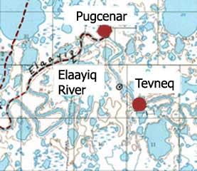
Map showing the site of Tevneq, located upriver from Pugcenar, and the small hand-drawn dot with a circle around it between Tevneq and Pugcenar marks the estimated location of Qakerlualek, a spring/fall camp. Spring camp at the mouth of the Qaqerlualek River was used by Akiachak people.
Photo By:
Base map compiled by Robert Drozda and Vernon Chimegalrea from information provided by Lower Kuskokwim Yup’ik elders in 1988.
Photo Collection:
AHP CPSU and ANCSA 14(h)(1) Historical and Cemetery Sites Collection [ANCSA Project], Bureau of Indian Affairs, Anchorage, Alaska